atlatec Mapping
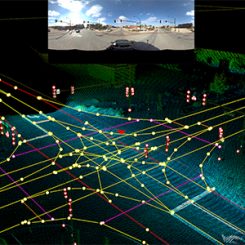
atlatec offers mapping as a service, they create high-accuracy HD maps. The maps are specifically tailored to your projects and to enable safe autonomy. The atlatec software computes trajectories, depth maps and orthophotos from the recorded imagery. A high degree of consistency is enforced in areas of self-overlap (loop closures). The software is able to extract relevant data like lane markings, road signs, guard rails, guideposts, road edges, poles and more. These objects are all reconstructed in your virtual environment and assigned the appropriate attributes. If you are not ready for your area to be mapped just yet and you would like to test a few areas we have areas of Detroit, Silicon Valley, Los Angeles and Las Vegas readily available for purchase.
The HD maps of atlatec can also serve as content in automotive simulators such as Virtual Test Drive, CarMaker, PreScan and others. Thereby your virtual testing is as random as the real world.

Features
- High-resolution orthophotographs
- Higher resolution than LiDAR-based maps
- Individually surveyed road markings
- Satellite images with map overlay available
- Accurately labeled signs and signals
- Available in OpenDrive, Lanelets2, Carmaker, and other formats.
- Uses lane geometry to calculate the common path of a vehicle
- Creates lane center lines to create paths for autonomous driving
- Detects different lane types to show one-way, bi-directional and turn lanes.
- Rich set of attributes for each object
- Model lane and road topology
Media